 |
| One of the Greeley Ponds |
Our plan was to hike a 4000 foot mountain on Friday morning. It would be one of the easier ones I have left. It is a north country mountain named Waumbeck. Unfortunately, Mother Nature had other plans. When we woke up, it was drizzling and the cloud ceiling was about 3500 feet. I'm not hiking a big mountain without getting the satisfaction of seeing the view.
The weather was going to clear around noon. I decided to do what I normally do on wet days, I hiked to a mountain pond. We went out to Greeley Ponds off the Kancamangus. It is an easy hike to two pretty mountain ponds. The trail goes from the Kanc past the ponds all the way to Waterville Valley. It is much easier to reach the ponds from the Kanc side than coming from the other way.
 |
| Mt. Pemi Trail going under I-93 |
The weather was clearing as we walked. By the time we got to the first pond, there was some blue in the sky. The sun started to evaporate the water on the ground and leaves. Even though the temperature was about 80, because of the sauna like moisture, it felt much hotter. Not to worry, there is a little beach at the pond where Laurie put her feet in the water and I looked at small fish.
We went to the second pond and lallygagged there for a while. When we got done hiking we went back to Lincoln and got pizza for lunch.
After lunch it was still only about 3 pm. On the spur of the moment, we decided to hike Mt. Pemigewasset. This is the mountain that the famous Indian Head Profile is on. As a matter of fact, the hike goes up to the top of the head. The mountian is just north of Whale's Tale waterpark. We hiked in from the north where the trailhead starts at the Flume Gorge Visitor Center.
The trail starts easy enough. It goes under I-93 and Route 3 by tunnel. After the initial warm up, the hike climbs gently up the mountain. It climbs roughly a thousand feet in 1.6 miles. The view at the top was fantastic. You can see most of Franconia Ridge ( part is obscured by trees). The main views are south and west. You can see for many miles to the south looking into the town of Lincoln and way beyond. We stayed up top as long as we dared and still make it down before dark.
When we got down, it was 7:30. Laurie took a quick dip in Echo Lake. I roamed the shoreline and
 |
| Lauri getting some sun on Mt. Pemi View is to the south |
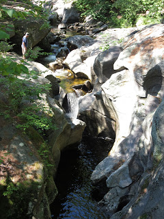
The next day Laurie had some major blisters on her heel. Any real hiking was a just a dream. We went to a place we wanted to check out in the Newfound Lake region called Sculptured Rocks Natural Area. The area is known as Grand Canyon of New Hampshire. First off... if anyone calls ANYTHING the Grand Canyon of (fill in the blank) they have never been to the Grand Canyon! No little gorge in New Hampshire can compare to a 270 mile long mile deep whole in the earth.
However the little gorge was cool. The water drilled a small little canyon about thirty feet deep and five hundred feet long. The rocks have been polished by the rushing water. There are neat natural potholes and weird rock formations. We drove there really looking forward to see this natural area in an area of New Hampshire I had never been too. It was nice, and I'm glad I went, however it was not worth going so far out of the way to see.
 |
| Lesser Yellowlegs |
After we left "the Grand Canyon" we found a Farmer's Market on our way to the highway. We bought some blueberries and an amazing homemade blueberry pie.
Photos below are of the Sculptured Rocks Natural Area


