1. It gives you an excuse to go hiking.
2. If climbing a mountain is just for the sake of "collecting" it, then your not getting the true experience of the mountains. Some peak baggers will reach a gorgous summit, touch it, and turn back around.
I agree with both points of view. You could make a winning argument for either case. For my part, I love views. When I hike a four thousand footer I spend as much time loafing at the summit as possible.
For the last fourteen years, I have been trying to do New Hampshire's 48 mountains over four thousand feet. Some years, I don't make it up at all. Other times I decide to hike other trails, and sometimes the weather doesn't cooperate. The trouble with hiking other trails or not going to New Hampshire is: I always have that cloud hanging over my head that I haven't finished them. So this year I am making a conscious effort to try to hike five mountains so I can finish them next year. When I finally finish them, I will not be starting any other list. There are too many trails I want to do that lead to lakes, shorter mountains, and waterfalls. There are some hikes I am itching to do again. And sometimes, you just want to go to a trout pond.
So the last few days I went to do a couple four thousand footers. I had a total of nine hikes left ( a couple of the hikes have two mountains). It is at the point that I have to do some of the mountains I don't want to do. Reasons one might dread a particular mountain are:
1. Long drive
2. Very hard or long trail (all mountains are not the same)
3. No views, so you are climbing just to check it off the list.
4. It is Owl's Head
Before I begin, I should say that I knew I was in good in enough shape to hike big mountains. I wasn't going to have any heart attacks. I also knew I was not in good enough shape to enjoy them. There was going to be soreness and pain on any big hike. Of course, I could have started with short easy hikes to build strength but that would have meant I wasted a whole weekend of being in New Hampshire...so I sucked it up.
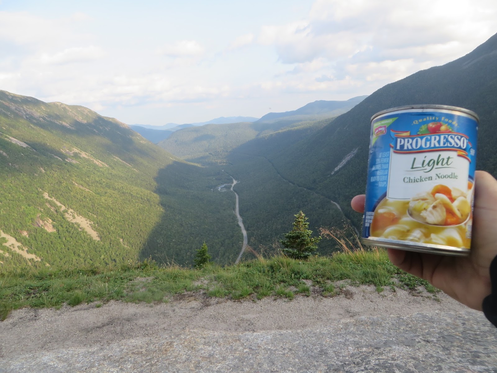
Wednesday night I drove up after work. If I can, I like to hike a smaller mountain in the late afternoon. I chose Mt. Willard. It is only 15 minutes from my camp. To reach the top it is only 1.6 miles and 900 feet of elevation gain

I had a can of soup and plums for supper. I made it up in 35 minutes. I thought I must be in really great shape to do that. Twelve hours later I was humbled by real mountains
Edgar Allen and his wife Virginia on the summit

Mount Webster and the impressive cliffs behind me

Thursday
Thursday morning I woke up bright and early. I had a fifty mile drive to my trailhead. My hiking plans for the day were the two Carters and Carter Dome. The hike from Nineteen Mile Brook trailhead started easy enough. I made it 1.9 miles to the Carter Dome Trail in an hour.

From there it is a long slog up seven switchbacks to Zeta Pass. You would think with a name like that it would be pretty. Nope, just a trail intersection in the woods. From Zeta Pass I could go to the Carters or right to Carter Dome. I did the Carter's first so when I ran out of water, I could refill at Carter Notch later. After a short while, you reach the wooded summit of South Carter.
 |
| Here's me flipping off the wooded summit. Notice the bend in my finger. I was born that way. Needless to say, I don't give too many people "the bird" |
From South Carter it is a fairly long walk to Middle Carter (North Carter is not an official 4000 footer). There is one incredible view between the two summits. The view faces the Presidentials.
The only view from the summit of Middle Carter was this amateur radio operator
. He carried a lot of equipment up the mountain.
From the summit of Middle Carter I went back by South and again to Zeta Pass. From Zeta Pass I could choose the short way up Carter Dome or a slightly longer way, .4 miles and an extra 150 feet of elevation to go over Mt. Height. This mountain has the best view in the range. It is 360 degrees. You can see deep into Maine, the Presidentials, and many other peaks. So I planned on taking the side
trip and eat my lunch there.
 |
| Two of my favorite mountains. The Baldface in Maine from Mt. Height |
 |
| Three of the Presidentials L to R Jefferson, Adams, Madison |
After I left Mt Height, I was treated to another summit without a view. Although a couple ledges were nearby, tha actual summit is wooded on Carter Dome.

When I got to the top of Carter Dome I drank the last of my Gatorade. This was planned as I'd been rationing all day. A mile and a half away was the Carter Notch Hut. I knew I could get water there. It was all downhill, so how hard could it be?...
Two and a half grueling hours later I made it to the hut. My knees were killing me. The trail was so steep and each step down hurt. This view below the text was taken after I'd been on the trail almost two hours. I couldn't believe I was still so far away. 

These two lakes below are the Carter Lakes. They are at the hut. They are beautiful. One abuts Wildcat and its cliffs. The other sits right against the cliff face of Carter Dome. They were the prettist thing I saw all day. After I refilled my water bottles I sat by the lakes and ate a snack. I couldn't stay long. It was already 5:30 and I still had four miles to go.


 |
| Tired and sore, I made it out at 7:30. I had time to get back to my site 50 miles away before dark |
Friday
Friday morning I woke up to three completely different but all equally surprising things
1. The second I opened my eyes I could feel a pounding migraine.
2. The wind was absolutely howling at least 40 miles per hour.
3. My knees did not hurt.
Despite my knees being okay, I thought any real hiking was unrealistic because of my head and the wind. After about 20 minutes I mustered the energy to get some medicine from my car and got back in my sleeping bag. To my surprise in the next thirty minutes both the pain in my head and the wind died down to nothing. I packed my tent and drove off.
I was trying to think of a small mountain to hike. As I was driving I realized I had no excuse to hike a 4000. My knees were okay and my headache was gone. This really only left me two options. I had to drive home after the hike and the closest two mountains ( by at least 30 minutes) I have left are Kinsmans and Owls Head. Kinsmans would have required more uphill but is considerably shorter at ten miles round trip. Owls Head on the other hand is eighteen miles round trip. Only one mile is considered hard the rest is a long boring slog through the woods.
No one wants to do Owls Head. It is by far the worst mountain on the 48 big ones. Eight miles walking through the woods. There are multiple stream crossings including Franconia Brook (really a river) .There is an extremely steep slide to reach the top, 1500 feet in .8 miles. Lastly, let me say again, nine miles each way. Owls Head, alone is enough of a reason to consider peakbagging a stupid endeavor. It sucks
However, I want to enjoy my last few hikes, so I chose to get Owls Head out of the way. I started at 8;30 am at the huge Lincoln Woods parking lot

Then you cross the river on a suspension bridge
. You can feel the bounce as you go over. It is right near the lot if you are interested.
The first three miles are extremely flat. That part of the trail is an old railroad track for a lumber company. Many of the ties can be seen in this picture

After you cross this bridge at 2.9 miles, you cross into the Pemi Wilderness

At 5.1 miles you come to this, Franconia Brook. No matter where I looked I couldn't cross it without getting wet. I took off my shoes, but my feet were so raw from the pounding the day before I couldn't walk on the jagged pebbles. I decided to leave my socks off and put my shoes back on. I walked across and walked sockless with wet feet for three miles until my shoes dried.

The first five miles were easy. The next three were just as flat. However, there was a lot of muck and blowdowns to climb over. There were multiple stream crossings to rock hop over.
It was also buggy. I did not make nearly as good time. |
| New Hampshire mud at its finest. |
After 8 miles you come to this. It is a cairn to mark the turn for the Owls Head. Within fifteen feet of this spot, the grade gets really steep.

After only.1 miles you come to this slide. I assure you, pictures do not do justice on how hard it is. Besides the steepness, the dirt is loose rock and pebbles. every step had to be calculated because of slipping

The view across to Franconia Ridge was really nice. Notice the dark clouds. I checked for a weather report at the Ranger Station before I left but they hadn't put it out yet. I ran across a hiker on the slide coming down he told me it was supposed to rain at 1 pm. He told me this at exactly 12:55

I knew I was battling the time and the weather. The slide was hard enough without rain. I took a chance the rain would hold off. I never plan on hiking this mountain again, so I couldn't turn back after eight miles. After .8 miles the grade gets much easier. For the last quarter mile it is flat. There are two summits, an old one and the one GPS says is the higher one.
Here is a pic of me at the larger and older cairn. Notice, another viewless summit.

At precisely 4:00 I made it down from the slide. It took me three and a half hours to do that two mile round trip (and find the other summit). At precisely 4:03 it started to rain. I had eight miles to go, but it was all safe. I didn't mind the rain at all. It turned out to be a shower lasting ten minutes. Just long enough to wet everything. Multiple times as I was rushing out I'd purposely shake branches above me to cool off.
Since the terrain was level on the way out I jogged short straightaways. I did miles eight through five in an hour. When I got back to the river, I just went across. I didn't try to find the easiest route. I just wanted to be done. When I got back on the Lincoln woods Trail and only had three miles to go, I was spent. I couldn't run anymore. As flat as it was I walked out. My quads were on fire. I got to my car at 6:52, but Owls Head is just a memory
 |
| I found this and some other iron at a river crossing. I'm sure it is part of the railroad or lumberjacks equipment from a long time ago. It is illegal to move or take these artifacts so others can enjoy them in the future. |
I'll be honest, this wasn't my most fun trip to the Whites. I did thirty four miles. In Thursday and Friday combined for 31 of that. I climbed about 8000 vertical feet. However, of the hikes I have left, the two that I just did were the hardest. After I rehydrated, I lost five pounds in that time period of two and a half days. Next week I'm going up again. However, I'm taking DJ's little sisters. We will not be doing any 4000 footers. We are going to concentrate on short fun hikes. I'm looking forward to it.
Things I learned:
I consider every camping trip a learning experience. This hike I realized I should put Iodine tablets in my bag of essentials. They would come in real handy when crossing rivers on very long hikes. I wouldn't have to carry as much water either. I have them, but they would do me a lot more good in my backpack than my camping box.
No comments:
Post a Comment